Updated: May 2026
Maumere Flores — Maumere to Larantuka Overland: 137 km Trans-F…
Maumere Flores is a curated Indonesia luxury tourism experience offered by Maumere Flores Voyages: handpicked routes, vetted operators, transparent pricing, and 24/7 concierge support across Indonesia.
- What makes Maumere Flores a premium experience.
- How Maumere Flores Voyages curates exclusive access and concierge logistics.
- Routes, seasons, and pricing transparency — no hidden fees.
Maumere to Larantuka by Road: A 137-Kilometre Lamaholot Coast Guide
The Trans-Flores highway between the eastern gateway and the Holy Week city is one of Indonesia’s most under-rated road journeys. Here is how we drive it, and where to stop.
The route in plain numbers
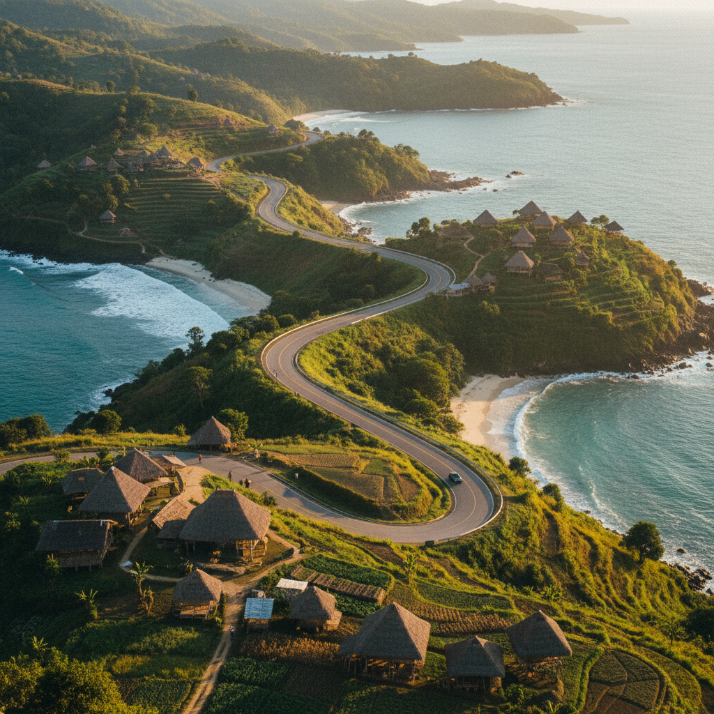
The Trans-Flores highway from Maumere to Larantuka covers 137 kilometres on Google Maps and around four hours of moving time on a normal day, plus another two hours of meaningful stops. The road is mostly two-lane sealed asphalt in good condition, with occasional rough patches near Hokeng where Lewotobi’s recent ash deposits have softened the surface. Most stretches hug the north coast within a kilometre of the sea; a handful climb inland through coffee terraces. We schedule a 07:00 departure from Maumere and a mid-afternoon arrival in Larantuka, which leaves comfortable margin for unforeseen ferry traffic at the Larantuka end.
Why drive instead of fly
You can technically fly Maumere to Larantuka by routing back through Kupang, but the connection is awkward, the saved time is roughly two hours, and you miss the entire Lamaholot coast. The road journey is the point. It is where you watch the geography shift from Sikkanese country into Lamaholot country, where the architecture of village houses begins to lengthen and the language at the warung counter changes from Bahasa Sikka to Bahasa Lamaholot. Travellers who fly arrive in Larantuka with no context for the coast they are looking back at; travellers who drive arrive having earned it.
Stop one: Bola coffee plantation
Forty kilometres east of Maumere, just before the village of Bola, the road climbs briefly through smallholder coffee terraces. We stop at a family-run plantation where you can see arabica drying on raised wooden racks and try a freshly roasted cup at the porch. The plantation has been in the same family for three generations and the eldest son speaks usable English. Total stop time is around forty minutes and includes a small morning snack of pisang goreng (fried banana) and Sikkanese coconut sugar.
Stop two: Hokeng overlook beneath Lewotobi
Around the seventy-kilometre mark the road bends inland and gives the first clear view of the twin Lewotobi volcanoes — Lewotobi Laki-Laki (male) and Lewotobi Perempuan (female), as the local Lamaholot tradition names them. Lewotobi Laki-Laki has been in elevated activity since 2024, and on clear mornings you can see steam plumes from the summit. We stop at the Hokeng ridge for fifteen minutes, listen to our driver read the latest PVMBG advisory aloud, and proceed only if the alert level is below three. We never push past an exclusion zone, full stop. From Hokeng the road descends back to the coast along a switchback that has been recently widened and resurfaced.
Stop three: Boru fishing village lunch
The lunch stop sits roughly halfway, at the small fishing village of Boru on the north coast. The warung we use has been on the same patch of sand since the 1980s. The signature dish is grilled mahi-mahi rubbed with green chili and lime, served with rice cooked in young coconut and a small side of sayur kelor. The whole meal usually runs to around ninety thousand rupiah per person and we factor that into the optional inclusions on a multi-day Maumere itinerary. While you eat you can watch the morning’s catch being weighed and sorted on the beach forty metres from your table. The pace forces you to slow down, which is the entire point of stopping here.
Stop four: Waiwerang ridge and the Solor strait view
The final stop is the Waiwerang ridge above the Larantuka strait. From here you can see the Solor and Adonara islands rising across a narrow channel of remarkably clear water, and on rare days you can see Lembata further beyond. The ridge is also the first place where the Holy Week procession context becomes physically obvious — the boats moored in the strait below are the same boats that participate in the Easter water procession that has run continuously in Larantuka for nearly five centuries. Our driver pauses here for ten minutes and then descends through the small market town of Waiwerang on the way into Larantuka proper. Travellers continuing the journey east can read more on our companion site at larantukaflores.com (plain text reference).
Ferry timing for Solor, Adonara and Lembata
If your plan is to continue from Larantuka to one of the eastern islands, the relevant ferry departures from the Larantuka pier run several times daily to Adonara and Solor with an additional connection to Lembata. Schedules are weather-dependent and rotate seasonally; we hand you off to our sister team at Larantuka who confirm the live timetable on the morning of your transfer. Read the broader trip context in our 5-day Maumere Flores private tour.
Driving in the wet season
From November to early April the road is still drivable but slower, with occasional surface flooding at low-lying culverts near the river crossings west of Boru. We move the schedule earlier (06:00 departure) to give buffer time and we add an hour to the total estimate. We do not run this transfer on days with red weather warnings from BMKG (Indonesia’s meteorological agency); we either delay by a day or, in rare cases, switch to a domestic flight via Kupang at our expense. Read the Wikipedia overview of Maumere and the Indonesia Ministry of Tourism portal at indonesia.travel for further regional context.
The scent of wild orchids and sea salt mingles as you venture deeper into Flores’ eastern reaches, revealing a landscape where ancient traditions thrive alongside burgeoning natural beauty.
Beyond the asphalt: The cultural heartbeat of Lamaholot
While the Trans-Flores highway offers striking vistas, the true essence of this region lies in its vibrant cultural tapestry, primarily woven by the Lamaholot people. These indigenous communities, spread across eastern Flores and nearby islands like Adonara and Solor, maintain a rich heritage of animist beliefs intertwined with Catholic practices. Our curated journeys venture beyond the main road, guiding you into traditional villages like Wureh or Lewoleba, where life unfolds at a rhythm dictated by ancestral customs and the seasons.
Here, you encounter master weavers creating intricate ikat textiles, a craft passed down through generations. A single, complex ikat cloth, hand-dyed with natural pigments from indigo and noni roots, can take up to six months to complete, each motif telling stories of lineage, cosmology, and daily life. These aren’t just souvenirs; they are wearable histories, representing a profound connection to the land and its people. Engaging with these artisans offers a rare glimpse into a vanishing art form, often culminating in an opportunity to acquire a distinctive, ethically sourced masterpiece.
Coastal sanctuaries and artisan encounters
The journey from Maumere to Larantuka is punctuated by spectacular coastal stretches, where pristine beaches meet the turquoise waters of the Savu Sea. Beyond the well-trodden paths, our itineraries reveal hidden coves perfect for a secluded swim or snorkeling expedition among vibrant coral gardens. Consider a stop at Koka Beach, a twin-bay paradise near Paga, where the white sands invite quiet contemplation and the local fishermen offer fresh catches grilled over an open fire – a simple luxury that speaks volumes.
Further along, the region is also renowned for its unique artisan crafts beyond textiles. In villages set along the coast, skilled hands transform local materials into exquisite pottery, intricate basketry, and even traditional wooden boats, often replicas of the elegant phinisi. These encounters are not merely transactional; they are an immersion into the local economy and a chance to witness the dedication behind each handcrafted item. Many of these communities welcome respectful visitors, offering insights into their daily lives and the sustainable practices that define their existence, providing a truly authentic and enriching cultural exchange.
Larantuka’s spiritual tapestry: A Holy Week prelude
As you approach Larantuka, the “Holy Week City,” a palpable sense of history and spiritual devotion permeates the air. This charming coastal town, with its distinct Portuguese colonial architecture and strong Catholic traditions, offers a profound counterpoint to the natural beauty encountered on the road. Larantuka’s annual Semana Santa (Holy Week) procession, dating back to the 16th century, is a UNESCO-recognized cultural heritage event, drawing pilgrims and visitors from across the globe. Even outside of March or April, the city’s spiritual pulse is evident in its ancient churches and the reverence of its people.
The city center, with its narrow lanes and colonial-era buildings, invites leisurely exploration. Visit the Katedral Reinha Rosari, a majestic structure that stands as a testament to centuries of faith, or wander through the local markets bustling with fresh produce and unique handicrafts. Larantuka serves as more than just an endpoint; it’s a gateway to understanding the unique blend of East Timorese, Portuguese, and indigenous influences that have shaped this corner of Flores, making it an memorable cultural and spiritual anchor for your journey.